Description: Outer metropolitan.
Name Derivation: Named after William Hughes 1862-1952, Prime Minister of Australia 1915-23.
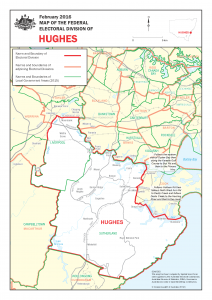
Area and Location Description: Hughes covers an area of approximately 265 sq km from the Georges River in the north to Cabramatta Creek, Maxwells Creek, Hoxton Park Road, Terminus Street and the Georges River in the west. The Illawarra Railway line, Old Princes Highway, Princes Highway, Farnell Ave, Audley Road and Hacking River make up the eastern boundary, with the Sutherland and Liverpool Local Government areas providing the boundary to the south. The main suburbs include Alfords Point, Bangor, Barden Ridge, Bonnet Bay, Chipping Norton, Engadine, Hammondville, Heathcote, Holsworthy, Illawong, Jannali, Loftus, Lucas Heights, Menai, Moorebank, Warwick Farm, Wattle Grove, Woronora and parts of Como, Jannali, Liverpool, Sutherland and Waterfall.
Area: 265 sq km (approx.).
Electors enrolled: 91 898 (as @ September 2008)
Industries: Lucas Heights Research Laboratories, light manufacturing industries, army base at Holsworthy.
State electorates: Hughes includes parts of the New South Wales Legislative Assembly electorates of Menai, Heathcote, Miranda and Liverpool.